10 Best Android Auto Navigation Apps to Get Directions While Driving
To make your journey easier, there are many apps that navigate to your desired destinations. Apart from just Google Maps, there are now many navigation apps for Android Auto even with offline navigation available. You can connect your phone to your car’s Android Auto and then you can focus on the road while navigating with these map apps
Here, we have handpicked the best Android Auto navigation apps you can use within your car’s head unit display.
Waze
Waze is now available on your car display with the Android Auto. The Waze app will alert you about traffic, construction, police, and crashes. Moreover, you will get a fast and instant routing change so that you can avoid traffic and save time.
From Waze, you are able to listen to your favorite music and podcasts from different apps including Spotify and Apple Music. Besides, ETA based on the live traffic data lets you know the time you will arrive. With this Android auto offline Navigation app, you can also find the cheapest gas stations around you.
Key Features: Collects map data | Travel times | Traffic information | ETA | Carpool facility
Download: Waze (Free)
Google Maps
Google Map can be easily connected to your car’s information system and then you can navigate faster and easier. The Android Auto navigation app maps over 220 countries and territories. Moreover, you also get real-time GPS navigation and traffic info. Also, you get to find information about the nearest hotels and explore the local neighborhoods right from your car dashboard.
Google Map’s offline navigation will help you drive through any terrain without an internet connection. Google Maps also have automatic rerouting which is based on live traffic. The real-time ETA helps you keep track of live traffic conditions. You can create a list of your favorite places and share it with your friends.
Key Features: Set route options | Pick your route preference | Explore in street view | Turn-by-turn navigation
Download: Google Maps (Free)
Sygic
Sygic is a completely offline and trusted navigation GPS navigation app. 3D maps are saved to your phone offline and you can access Syginc navigation without an internet connection. You will get free map updates multiple times a year in Sygic.
You can use your voice to control the Android auto navigation. It gives you correct directions and the names of the streets. Sygic also provides walking directions and other tourist attractions. The Android auto offline navigation app has a Dynamic Lane Assistant that will guide you into the correct lane.
Key Features: Offline 3D maps | Speed limits | Head-up display | Voice navigation | Real-view Navigation
Download: Sygic (Freemium)
AmiGo
AmiGo gives you an ad-free map navigation experience. You can set up AmiGo completely for free, set up your destination, and start your ride. You will be guided to the fastest ways as AmiGo takes record of live traffic, speed cameras, and road hazards. You will also get alerts about the speed cameras on Android Auto.
You will get visual guidance of the maps that will give you directions to all destinations. It is also able to pinpoint incidents along the route in the overview of the map. Besides, you are able to auto-start and stop the Android auto offline navigation app via Bluetooth connection.
Key Features: Trusted arrival times | Maps overview | Hands-free protocol | Average speed check zones | Mobile speed camera alerts
Download: AmiGo (Freemium)
MapFactor
MapFactor is a free GPS navigation app with free offline maps for your car head unit. The Android Auto navigation app has regular free map updates. You can navigate over 200 countries without an internet connection. Besides, MapFactor provides speed limits, camera warnings, and many more over different languages.
The Android auto navigation app has door-to-door route planning. The 3D-mode in the app gives you a realistic view of visual maps display. It also has a dark mode for both your phone and car screen. There are no auto-rerouting options, but you can still get alternate route information with MapFactor.
Key Features: Intuitive voice navigation | Door-to-door route planning | Cross-border routing | Optimization of waypoints
Download: MapFactor (Free)
Genius Maps
Genius Maps is a free application that helps you with offline route planning, exploration, and navigation app. You don’t need an internet connection to navigate and search in the Android Auto navigation app. There is a seven-day free trial in the auto offline navigation app that can be activated any time.
You can enable pro guidance for turn-by-turn voice instructions in any language. It also gives speed limit alerts, POI along routes, and unlimited map updates. Live traffic feature in Genius Maps will let you know about road works and accidents.
Key Features: Offline route planning | Turn-by-turn voice navigation | POI along routes | No roaming costs | Speed limit alerts
Download: Genius Maps (Freemium)
SpotHero
The Android Auto app can be connected to your car screen and then navigate to your desired places. SpotHero is mainly used to book parking slots. You can prepay and park and pay with Google on SpotHero. This will be a convenient way to find and reserve parking in major cities like New York City and Los Angeles. Also, you get fifty percent off when you book in advance.
For booking your parking slot, firstly, you have to enter the date and time. Secondly, you have to prepay to reserve your parking spot. Then, you can follow the directions on your parking pass to your spot. Also, in SpotHero, you are able to create a business profile which will separate your personal parking expenses from business. You can do all these right from your car’s screen over Android Auto when the SpotHero is installed on your phone.
Key Features: Access controls | Mobile parking signs | Payments processing | Ticketing | Reserve parking slot
Download: SpotHero (Free, Premium)
PlugShare
PlugShare is the most accurate and complete EV charging stations map for North America, Europe, and many more countries. We can say, it is the most reliable in finding EV and Tesla charging stations. You can filter the PlugShare map by plug type. Plug types include Level 1, DC Fast Chargers like the Tesla Superchargers, and SAE/CCS.
Users can contribute station reviews and photos to help drivers make the most informed charging decisions possible. You also get notifications if enabled about the new charging stations that are installed nearby. Besides, you can pay for charging from the app itself.
- Accurate and complete EV
- Charging station reviews
- Notifications on new charging stations
Key Features: Access a database of 160,000+ charging stations | Turn-by-turn navigation | Get global coverage | Largest EV driver community
Download: PlugShare (Free)
NEXTCHARGE
NEXTCHARGE will show you electric vehicle charging stations nearby. Over 150,000 charging stations are shown by the Android auto navigation app. The app has a simple user interface that makes it easier to read and locate charging stations. Besides, you can enable the map mode to find stations within your area.
The Android auto offline navigation app has a list mode that will show you the description and status of the charging stations. The details also include some basic information like time, distance, and plug types. The Android auto offline navigation app will give you a convenient service like the station’s real-time status.
Key Features: Convenient service | Customizable | Includes itinerary, review & status | Map mode | List mode | Status & description of charging station
Download: NEXTCHARGE (Free)
ChargePoint
With ChargePoint, you will be able to open EV charging network with over 100,000 charging spots. Besides, you also get to know when these stations will be available in real-time. In order to start charging, all you have to do is tap on any ChargePoint station. You also get a real-time update about your charging status.
The Android auto navigation app has filters which you can add so that you only see the charging stations that work with your car. Also, you can add a filter for fast charging as well. You get advice and tips from drivers about charging at a particular station. In addition, you can see charging history and trends including miles added and cost from within the ChargePoint Android Auto app.
Key Features: Start charging | Get notified | Use filters | Roaming | Driver tips | Charging activity
Download: ChargePoint (Free, Premium)
Navigation apps always make your journey easier. When you get such navigation apps on Android Auto, driving becomes much more seamless. You saw that some of them show you navigation to your desired locations. On the other hand, some others on the list lead you to the charging stations for your electric car. Try them out on your next journey and do let us know which one you had the best experience with.
Disclosure: Mashtips is supported by its audience. As an Amazon Associate I earn from qualifying purchases.
Bluetooth GPS 1.3.7
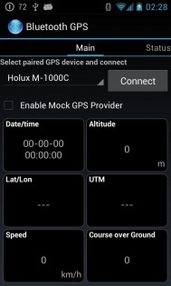
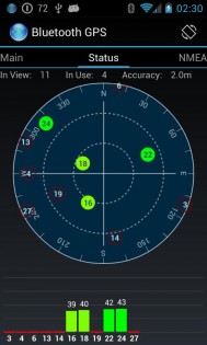
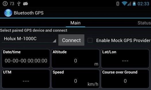
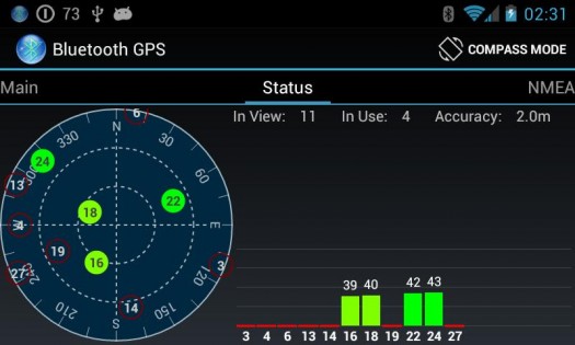
Bluetooth GPS — приложение для подключения внешних GPS приемников (NMEA) и использования их данных в других приложениях.
На Android-устройстве требуется включение опции:
- (english) Settings / Applications/ Development / Allow mock locations
- (русский) Настройки / Приложения / Разработка / Разрешить фиктивные местоположения
Эта опция позволяет использовать навигационные программы и карты совместно с GPS-приемником, такие как Google Maps, GPS Status, RMaps, OruxMaps, NDrive, C:Geo, Навител и другие
Sygic Aura на текущий момент не может использовать эту опцию.
Для устройств Samsung Galaxy S/Tab и некоторых остальных девайсов Samsung необходимо сначала включить внутренний GPS до соединения с внешним GPS-приемником во избежание вылета приложения
GPS-навигатор с Bluetooth

В наше время производители стараются выпускать многофункциональные устройства. Примером могут служить камерофоны, планшеты, практически заменяющие компьютеры, электронные книги с плеером и Wi-Fi. Исключением не стали и GPS-навигаторы. Такой гаджет теперь может не только показывать местоположение и скорость на карте, но и связываться с другими устройствами, например, телефоном с использованием Bluetooth (блютуз).
С помощью такого соединения можно установить интернет-подключение. Возникает вопрос: зачем же на навигаторе нужен доступ в интернет? Ответ достаточно прост: во-первых, для использования различных сетевых сервисов, отслеживающих пробки в режиме реального времени, а во-вторых, для совершения телефонных звонков и ответа на них прямо с навигатора. Первое немаловажно для жителей крупных городов, где в крупном заторе можно простоять несколько часов, а неожиданное ДТП и, как следствие, затрудненный проезд иногда способствует опозданию на важное мероприятие. Трудно поспорить с тем, что возможность избегать пробок — большое преимущество, позволяющее рассчитать время пути практически до минуты. Возможность же отвечать на звонки прямо с GPS навигатора пригодится тем водителям, которые беспокоятся о своей безопасности, но не прочь поболтать по телефону по дороге.
В таких устройствах для соединения с телефоном обычно требуется выполнить несколько простых действий. Сначала необходимо включить блютуз на телефоне и сделать устройство видимым для всех. После этого нужно настроить сопряжение устройств — обычно в меню навигатора есть такой пункт. После этого можно прямо на экране навигатора набирать нужные номера. При смене телефона требуется удалить его из списка устройств на GPS приборе и настроить сопряжение с новым.

Стоит отметить, что беспроводная технология применяется не только в таких Bluetooth навигаторах. В последнее время достаточно популярны стали GPS-модули, соединяющиеся с телефонами и планшетами при помощи блютуз (Bluetooth). Такое устройство представляет собой небольшую коробочку, которую не составит труда положить в карман или просто в сумку. Обычно они имеют собственные аккумуляторы, заряжающиеся по USB. Зачем же нужны внешние модули, если можно купить полноценный прибор?
У некоторых людей уже есть сенсорный телефон с большим экраном или планшет. Если объединить планшет и внешний GPS-модуль, получится устройство, намного превосходящее возможности навигатора. Такое устройство будет незаменимо для путешественников без автомобиля — ведь неудобно возить с собой и телефон, и планшет, и навигатор, кроме того устройство не будет сильно разряжать планшет, ведь работает оно с помощью собственного аккумулятора.
Как же подключить внешний GPS-модуль к смартфону или планшету? Для этого достаточно установить специальное приложение для навигации (скачать его не составит труда), включить Bluetooth на устройстве — и блютуз-навигатор готов! Если планшет поддерживает 3G, то без проблем можно воспользоваться и сервисами отслеживания пробок.